 Few alternatives have emerged to ensure that Google navigation data are stored in cache in order to be consulted once we are not connected to the Internet. Although the same Google Earth caches, no one is certain where it is stored, so as to transfer it to another disk or keep it if we install a browser’s new version or formatting the machine.
For now StitchMaps has been an outlet for downloading images, but the alternative of downloading it in a mosaic georeferenced form, had not yet been seen like in this case iin which it can even be downloaded and loaded into ArcGIS with different levels of scale.
These two solutions that I will present are interesting but don’t work with Google Earth but with Google Maps. Although, they are an economical alternative to this intention of retaining data navigation in a controlled way or it can be load from ArcGIS at different level approach. Both are created by the Offline Soft Company.
 Map View
This is a very powerful browser that allows seeing simultaneously the layers images and maps. But more interesting is that its technology allows that areas that have been navigated are cached in a folder that you can choose.
In this way, information can be consulted again even when it is offline and the cache’s target can be chosen as a path on the server so that all users can view this data without consuming the Internet gateway. Also this folder could be transferred to another machine… great.
The other interesting things, is that places can be stored as tabs, so that it is possible to see several windows without having to be navigating to each zone.
For less than U$35 it seems an interesting investment, the trial version can be downloaded so we can’t buy what we have not tested.
Here you can download the trial version of Map View.
 Map Export
Map Export is a GIS oriented-development, since it allows you to download and export Google Maps’ images in georeferenced tile. It is always possible to choose between Google satellite Images, Street Maps and Terrain.
But let’s look what this download has that guides it to the GIS:
1. Image downloads
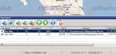
Map Export can download images in mosaic to a folder that you can choose. You can select the window coordinates to download it manually or with a window on the map. You can also choose the type of layer, and then in the bottom panel it shows the downloading, amount of images and controls to pause or resume the descent.

It is interesting that this downloads’ driver can do that different tasks may run at the same time, you can also configure a dialup, where if the connection is dropped, resumes the download while returns immediately.
2. Different levels of approach
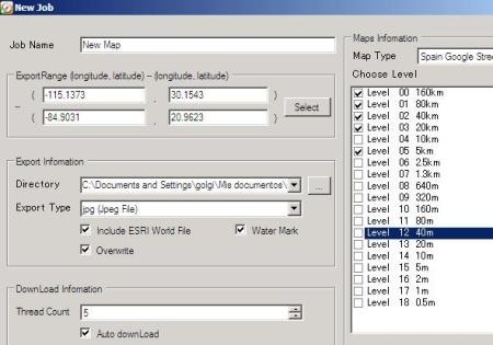
The right panel allows you to download 18 different zoom levels, and for each one creates a folder with the mosaic of images.

In this case, I’ve selected 5 levels, with JPG images, as you can see; it also created the JWG file so as when it’s called from a mapping program it come georeferenced.

You can choose omp, jpg, gif, png, and bmp formats. These different levels scale’s feature is done better than with Stitch Maps which only allows downloading one level at once, and although that left down georeference, the fact that it merges into one entity, makes it lose the consistency between different levels of approach as the calibration file which only calibrates the outer edges.
With the trial version it can only be downloaded images until the 11th level, with an approximate height of 80 meters.
You can do this with Google Earth Enterprise but under the Google’s crazy rules, for example, doing this with Map Export is possible, creating an own image server using the data from Google.
3. File for ArcGIS
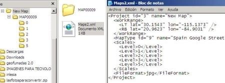
By downloading the images and choosing the option “include ESRI world file” it creates a xml file that handles the tile to be loaded from ArcGIS, because if you notice, the file contains the projection of images and folders where images are stored at different scale.

Map Export seems to me an excellent solution for downloading maps from Google Maps, so, well used it’s a worthwhile investment.
Here you can download the Map Export’s trial version.
For more information you can consult OfflineSoft’s web page.
 Autocad Software, Bentley Microstation, Gis Google Earth, Gis System Geomate Provides Services For Complete Gis Software And Solutions, Autocad Software, Autocad Courses, Bentley Microstation, Microstation Software, Gis Google Earth, Open Source Gis And More.