A common desire to AutoCAD user is connecting to Google Earth, so as to be able to work on the image that 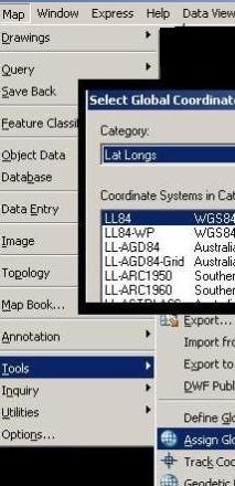 toy has, but its accuracy is questionable, every day we find better material but it is useful rather than having nothing. Today we will see at least two alternatives to do so:
A. With the ImportGEImage command
This is the implementation of that laboratory toy, integrated since the AutoCAD 2008. This requires just three steps:
1. Set the units. They must be in meters, you only need to enter the UNITS command, and make the adjustment.
2. Assign projection. This must be in lat/lon and with WGS84 Datum. To do so, apply the command sequence:
Map > Tools > Assign Global Coordinate system
Then select Lat Longs, LL84, with negative west.
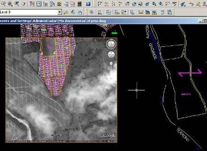
3 Import the image. We wrote the ImportGEImage command and ready. For some reason the image generally occupy motion and rotation but there is grayscale as it is the agreement of the two companies. To send an image to the background, touch on the edge, right mouse button is pressed and choose “display order > send to back”
B. Using Plex.earth tools.
This tool is from Plexscape, which together with XANADU presents an interesting solution to integrate Google Earth and versions 2007, 2008, 2009 and AutoCAD 2010, for Civil3D, Map, normal AutoCAD and Architecture. It has some similarities to the features bring by integrated Microstation.
1. Install Plex.Earth tools. It needs to be downloaded from Plexscape page, when installed, choose the AutoCAD version. When it runs for the first time, it gets up a panel to register the version; so we must provide an email address and go to the account to receive the link that is sent immediately. No matter if it is installed for different versions of AutoCAD, it only activates once and with the PLEXEARTH command arises the menu, in case it doesn’t do when AutoCAD opens.
It is understood that the dwg file must have an assigned projection and metric units of work.
2. What does Plex.Earth do? The best it has is that we can work in UTM, without having to switch to geographical coordinates. Choose the region and then the zone in the boxes on the left. Few smokes (Spanish Idiom: “fumadas” in this case means a particular and probably useful or brilliant idea) gain my attention at first glance, alter a comment in one of my posts, I decided to try it and it has impressed me its practicality. Now I’ll tell you how what does it do:

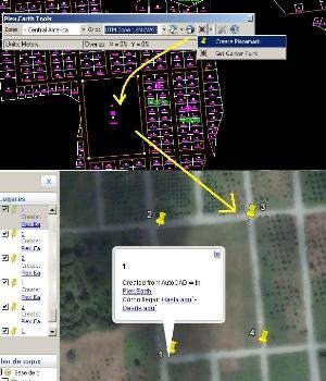 Synchronize AutoCADview with Google Earth. This is done with the second icon, when it‘s selected it calls the box and immediately moves Google Earth’s view to synchronize both.
- Put marks on Google Earth. This is done with the third icon, when it is activated; lets you place points that will be created in Google Earth. It is possible to make MULTIPLE points and assign them a description with the NAME option. In the example, I’m using a map of a new urbanization, which in Google Earth’s image is still an African palm plantation.
- Get the focus of Google Earth. Always in the third button, and putting a point in AutoCAD, with the center of the window that has deployed Google Earth.
- Import Google Earthcurrent view. This is with the first icon, in Import current view, and what it does is go to Google Earth, copy a print screen, get the extent and bring it as image. Interesting, better than the tool brought in AutoCAD because it comes in colors and with a better resolution.
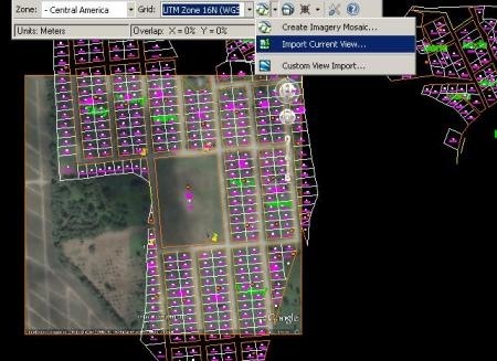
- Extract image tile. The best I’ve seen, this task is done from the first icon, with the “Create imagery mosaic” option, it just request us to define the area, then it asks how many boxes will the tile have and it arises a panel where we can choose if the image will be downloaded in color or grayscale, you can opt for automatic download and also for personal download, ignoring the ones you aren’t interest in with the “skip” option.
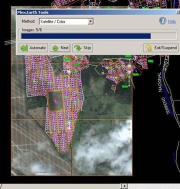
The last button is for setting things like:
- Units of work.
- Extra Margin of image: this is great for Google Earth’s compass and watermark so they lie outside the box.
- Timeout: How many timeout needs the capture to be done. We must increase the default time according the type of connection we have.
- Image’s format: they can be jpg, png, bmp, gif y tif
- Image’s path: where downloaded images will be saved, there is an option to keep them in the same path of the dwg file.
![]() The trial version is fully functional for 7 days or a maximum of 40 images. The forms of licenses range from $23.80, depending on time and amount of images, to licenses of 6 months or a year.
The trial version is fully functional for 7 days or a maximum of 40 images. The forms of licenses range from $23.80, depending on time and amount of images, to licenses of 6 months or a year.
 Autocad Software, Bentley Microstation, Gis Google Earth, Gis System Geomate Provides Services For Complete Gis Software And Solutions, Autocad Software, Autocad Courses, Bentley Microstation, Microstation Software, Gis Google Earth, Open Source Gis And More.
I like it
Olá, tem um plugin para o autocad, zwcad e gstarcad que possibilita inserir imagens do google maps e do bing maps, importar elevações para o cad, exportar do cad para KML e visualizar no goolgle earth, importar KML para o autocad e muito mais!!
Veja ele na minha página:
http://tbn2net.appspot.com/showpac?pacid=TBN2CAD
E também na loja de aplicativos da autodesk:
https://apps.autodesk.com/ACD/pt/Detail/Index?id=525570879147558726&appLang=pt&os=Win32_64