TRANSLATION NOTES: Please read some comments at the end of this post.
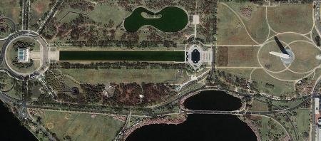
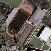
After its recent launch, on September 6 it has already been shown the first high-resolution images taken by the GeoEye-1 satellite.

 0.41 meters resolution, that’s enough, considering that the best approach had walked through the meter.
It should be seen what can be done with a product like this for cadastral purposes where absolute precision is relevant since this image already has the resolution used in an orthophoto taken to flight because difficulty lies in being able to improve its absolute precision since this has been rectified with a rather simplified terrain digital model.
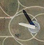
We must understand that this resolution does not mean precision but rather the area covering the pixel size, note how’s seen the obelisk, which shows the inclination compared with a lower height work. It is clear that this work has a good relative precision, so the river goes “over there”; however it is not the same the river axis or the water-divisor of a mountain used to define a basin for environmental purposes than “the edge” identified in a fence, whose absolute precision can be by 25 meters, but the owner would be willing to drive a dagger to fight for 25 cm.
 They have not said much with this announcement, but we do not want to move from critics in the style of Ken Alder’s book called “the measure of all things“, so here we translate Matthew O´Connell’s poem, the pure (*) embers of GeoEye:
“We are pleased to launch the first images from GeoEye-1, which brings us closer to the beginning of commercial satellite operations and sales to our customers. This is an important moment, and we thank our employees, customers, especially the Geospatial Intelligence National Agency, strategic partners, vendors and investors for their support. ”
We can be critical in demanding what this product can not give, but we must remember that it is surprising that this image was taken at a great amount of meters (*) height and a speed of 4.5 miles per second… nothing to do with the romance of a plane flying at 5 thousand feet or the wonders of the Pict’Earth’s boys.
In conclusion, we should expect much of this product after the aroused expectations, but still it isn’t clear how to obtain these images and the prices of them. It is possible to see other examples on this link and if you want to be aware of Geo-eye novelties or communications, this service can be subscribed.
TRANSLATION NOTES:
(*) mero: In its pure sense, it means pure, simple.
(**) chorromil: This jargon means a very big quantity.
 Autocad Software, Bentley Microstation, Gis Google Earth, Gis System Geomate Provides Services For Complete Gis Software And Solutions, Autocad Software, Autocad Courses, Bentley Microstation, Microstation Software, Gis Google Earth, Open Source Gis And More.