It has been released the 2.0 version of portable GIS, a simply wonderful application that can  run the necessary programs for spatial information management using both desktop and web interfaces; through different devices like external drives, USB memory sticks or even digital cameras.
What’s its weight?
The installer file weighs 467 MB, but it takes at least 2GB USB free to install it, because once unpacked and running, the required space is nearly 1.2 GB.
Programs included in it
It’s amazing what it does, because from a USB drive can run the following programs:
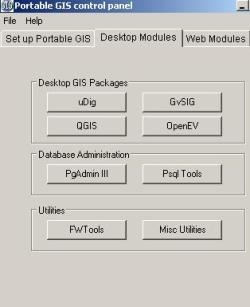
Software for Desktop GIS
- uDig (1.1.1)
- GvSIG (1.1.2)
- Quantum GIS (1.02)
Handlers databases:
- PostgreSQL (8.4.01) (pgadmin III and PSQL Tools)
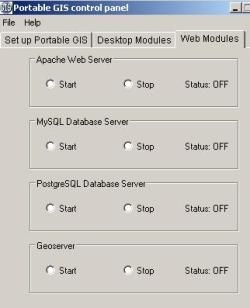
Web Services programs:
- Database server MySQ
- Postgre SQL Data server
- xampplite: PHP,
- Apache (1.6.2)
- Geoserver (1.7.6)
As additional applications:
· FWTools: OGR, GDAL, python, mapserver, openEV (2.4.2)
· Tilecache (2.10)
· FeatureServer (1.12)
· pgAdmin III (1.10)
· OpenLayers (2.8)
And these utilities come also in this pack:
· SqlSync (synchronization platform for databases)
· GeoMetadataExtractor (extracts metadata from georeferenced images)
· Shp2Text (convert shp files, with columns of coordinates)
· Ogr2Gui (for OGR GUI toolkit)
· ShapeChecker (Check and corrects corrupt shape files)
 How does it work?
Simply download the installer, run the file and choose the drive where you want install the program. This creates an executable that contains the menu, a folder called “usbgis” containing all programs and even an autorun.info file.
Whenever you connect the USB, it needs to be run “setup Portable GIS”, so that the system can recognize the path the browser has assigned to the disk. After this, you only have to use the program, and that’s all. It’s ideal for working with netbook computers, or for leaving it on a memory so as to be traveling or bouncing between offices without laboring in a fixed pc.
One of the biggest attractions are the server type applications, in this case Apache or GeoServer, that, only for the first time, holds a long time in learning how to install it; in this case, it’s only necessary to press “start” or “stop” to finish the programs.
Programs such as OpenLayers, Tilecache and Featureserver are executed from index.html file, once raised the Apache Server (http://localhost).
For QGis, which includes Grass, just select the directory to run it for the first time (..usbgisappsQuantum GISgrass). It’ll also be necessary to do so if you connect to another computer and the system assigns a different name to the unit.
PortableGIS is served under GPL and works only on Windows operating systems.
You can download it from here
 Autocad Software, Bentley Microstation, Gis Google Earth, Gis System Geomate Provides Services For Complete Gis Software And Solutions, Autocad Software, Autocad Courses, Bentley Microstation, Microstation Software, Gis Google Earth, Open Source Gis And More.
Hello,
the link for download is breaking …
How dll the last version.
Fred (F4EED http://f4eed.free.fr)